
Cold War Berlin Maps: West Berlin 1957 & East Berlin 1966

Maps of Cold War era Berlin show you the stark divisions between both sides. Here, together with my pal Steve who produces excellent videos about East Germany on Instagram, TikTok, and YouTube, we’ve compared a couple of maps from our respective collections.
I’ve brought a beautifully-coloured West Berlin transport map from 1957 to the table, and Steve’s got a map of East (and only East) Berlin from 1966.
There are links below to view the maps in high resolution. Time to search for your house/school/office!
Click the map to view in high resolution
The 1957 West Berlin Map: Berlin Before the Wall
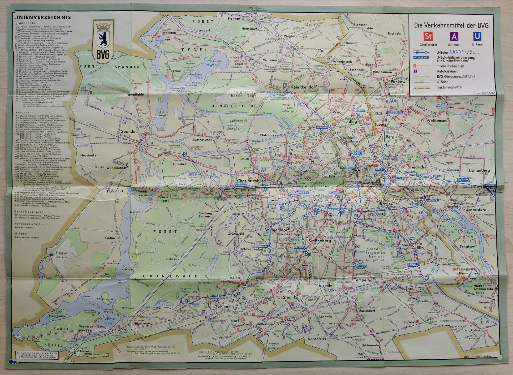
This West Berlin map, from 1957, was created by Berlin’s local transport authority, the BVG, a few years before the construction of the Berlin Wall in 1961. It shows a city that’s divided, sure, but not yet physically. Because this is fundamentally a transport map - the reverse side even shows you fun excursions you can do by bus! - it shows both sides of the city. This is because, weirdly, even though Berlin was now effectively in two separate countries, they continued to share bus, tram, U-Bahn, and S-Bahn services.

The dark yellow line shows the border that would become the Berlin Wall in 1961
In fact, the West Berlin map even shows an U-Bahn station in East Berlin named after Walter Ulbricht, the East German leader, although the old name (Schwarzkopffstrasse) is still clearly visible, too. Today the station is called Naturkundemuseum (natural history museum) and has dinosaurs set into the walls. Ironically, Walter Ulbricht Stadion station was among the first to be closed to East Berliners when the Berlin Wall went up… and on whose orders was the Wall set up? Walter Ulbricht.

In contrast to East Berlin, West Berlin would publish the names of stations on the other side of the Berlin Wall

Close up - you can see the path of the Wall marked in grey. Walter-Ulbricht-Stadion has been renamed ‘Stadion der Weltjugend’, ‘Schwarzkopffstrasse’ is now gone
In fact, the East Germans wouldn’t care so much about Ulbricht’s legacy in U-Bahn form either. The station was renamed pretty much the moment the man stopped breathing in 1973. I have to say, it was an odd choice to rename a station that could only be used by border guards at the time, but it’s not the strangest thing the communists did.
Weirdly, despite the East renaming their station, it’s conspicuous by its absence on the their own maps, as we can see from the next one from 1966. You can see a transport map on the right side showing East Berlin’s now relatively puny S- & U-Bahn network. Large chunks of the present-day U6 and U8 lines ran through East Berlin, as did the North-South S-Bahn tunnel, but their stations were closed off, allowing trains carrying West Berliners to run under East Berlin. These became known as the Ghost Stations, but that’s a story for another time.

Click for high resolution
The 1966 East Berlin Map: Who Needs West Berlin?
The U6, U8, ans S-Bahn weren’t the only thing missing from East Berlin’s maps, though. One glaring omission is… the entirety of West Berlin!
The Berlin Wall was set up to stop so many East Germans from leaving the country. East Germany was founded in 1949, and by 1961 an estimated 1 in 6 of its citizens had fled to the West. With so many of them leaving, and around half of them under 25 years old, East Germany had to act quick, or face an existential threat.

The East Berlin S- & U-Bahn map ca. 1966. Note, the East had a huge tram network not pictured here
The Wall was set up overnight on August 13th, 1961. Berlin’s border became physical, and in many people’s minds, permanent. Over the years relations between the two would ease up, but this map was published in 1966 - the height of tensions between the newly formed capitalist & communist Germanys.

East Berlin ends right here. We don’t talk about West Berlin…
Omitting West Berlin served a dual purpose: it reinforced the East Germany’s narrative of West Berlin as a separate place, a foreign country, a place we don’t trust. The East German authorities wanted to convey that East and West Berlin were separate sovereign entities, with no need for East Berliners to concern themselves with the West. You can’t go there, don’t think about it.
Discover more Cold War Berlin History
I have a Cold War & East Berlin private tour that’s really popular. If you’d like to join just take a look, and get in touch!
I’ve also created a huge list of Cold War sights in Berlin you can explore, and I’ve marked them all on a map for you, too. Go nuts!
For more Cold War stories you can check out my blog, my podcast, or my videos across social media.
For all of my tours, check out my homepage here.